World
UN’s New World Map: Africa Finally Gets Its True Size

Introduction
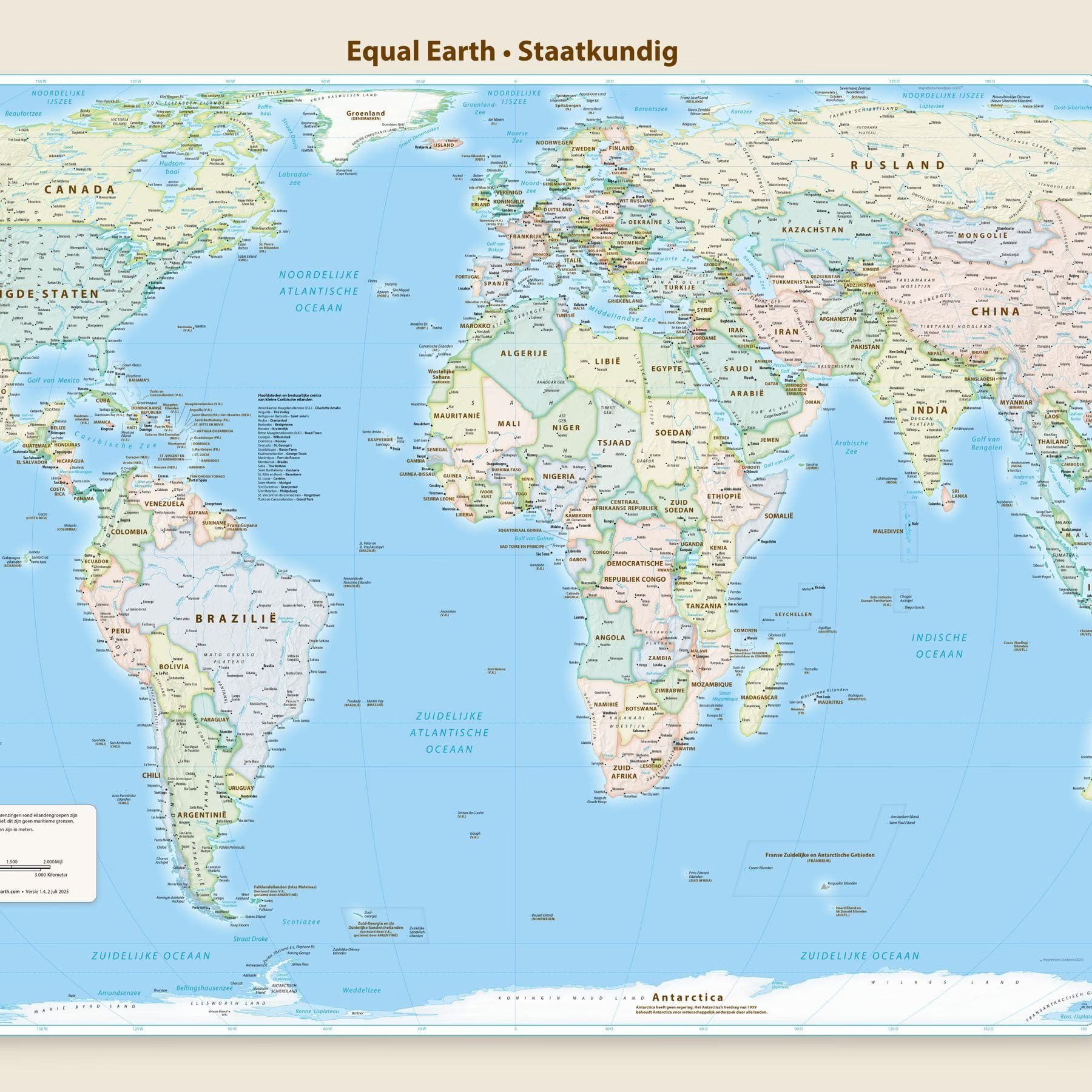
A historic shift is unfolding at the United Nations. The UN General Assembly is considering a landmark resolution to replace the centuries-old Mercator world map with the Equal Earth projection—a scientifically accurate map that finally represents Africa’s true geographical size. The proposal is being led by Togo with the full backing of the African Union, marking one of the most significant efforts to reshape how the world sees Africa.
Why is the map changing?
For nearly 500 years, the Mercator projection has been the world’s most widely used map. Designed in 1569 for maritime navigation, it was excellent for sailors—but not for accurately representing land size. Because of its projection, countries closer to the poles appear much larger, while equatorial regions such as Africa appear dramatically smaller.
The distortion is enormous


5
Although many people believe Greenland is almost the same size as Africa, the reality is striking:
| Region | Actual Size |
|---|---|
| Africa | 30.37 million km² |
| Greenland | 2.16 million km² |
Africa is about 14 times larger than Greenland, yet traditional maps often make them appear similar.
What is the Equal Earth projection?
The Equal Earth projection, developed in 2018 by an international team of cartographers, preserves the true relative area of continents. Unlike Mercator, it does not exaggerate Europe, North America, or Greenland at the expense of Africa and South America.
Its purpose is simple:
- Represent continents according to their real land area.
- Improve educational accuracy.
- Remove long-standing geographic distortions.
- Promote a more balanced global perspective.
Why Africa is leading this movement


4
The campaign, known as #CorrectTheMap, argues that inaccurate maps have subtly influenced how the world perceives Africa’s importance. The African Union endorsed the initiative and tasked Togo with presenting it before the United Nations. According to Togo’s Foreign Minister, Robert Dussey, this is a scientific discussion rather than a political one—one rooted in geographical truth.
Why this matters beyond geography
Changing a map is about more than cartography. Experts believe visual representation influences education, media, economics, and even international policy. When Africa appears smaller than it truly is, it can reinforce outdated narratives about the continent’s global significance.
Africa’s real scale
You can fit all of these inside Africa:
- United States
- China
- India
- Japan
- Mexico
- Much of Europe
…and there would still be land remaining.
What happens if the UN adopts it?
If approved, the resolution is not legally binding, but it could encourage widespread adoption across:
- School textbooks
- Universities
- Government publications
- International organizations
- Digital mapping and educational platforms
The African Union, UNESCO, and technology partners are expected to discuss implementation in 2027.
A defining moment for Africa
Africa is home to over 1.5 billion people, contains 54 sovereign nations, and possesses some of the world’s richest natural and human resources. The proposed UN map is symbolic—it recognizes that accurate representation matters in a world increasingly shaped by data, education, and global perception.
As the world debates this historic resolution, one message stands out clearly: Africa is not getting bigger—the world is finally seeing it as it truly is.